

lew
-
Posts
13,040 -
Joined
-
Last visited
-
Days Won
152
Content Type
Events
Profiles
Forums
Store
Everything posted by lew
-
I bought my Skeeter from Hastings Marine, great folks to deal with.
-
Best one I ever owned was a Guest charger.
-
Sunny warm & beautiful down here Jason, but I guess you don't want to hear that
-
Hope they get it fixed up OK, it's a good site.
-
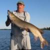
Fantastic picture Mike !!
-
I ran a call one time where a kid was making a pipe bomb in his kitchen and it exploded and blew both his hands off. I didn't feel the least bit sorry for him.
-
Call Whelans over on Chemong Road Jer. They probably don't carry it but should know who does in the area. 705-292-9565
-
The water levels don't appear to be as high...yet...as a couple years back. This is a picture I took of the locks at Yonges Point 2 or 3 years ago and you can see the water is right up to the top of the cement wall where the boats tie up waiting to pass thru. And this is the same lock yesterday, the water is probably a foot higher than normal but still alot lower then before. And this is the dam at Yonges Point yesterday. All this massive amount of water heading south thru the Kawarthas has to funnel thru the narrow Ottonabee River from Lakefield down to Rice Lake and it's a real balancing act for those in charge. If they let too much water thru at once they flood the homes on the river, and if they don't let enough thru, they flood the area north.
-
Mileage will depend on what style & size motorhome you'll be driving. My folks used to have a class "C" and it averaged around 10 MPG. Great way to travel too.
-
Amazing what a difference a few days can make Norm !!
-
50 odd years ago we used to go down those rapids on rubber tubes Norm, don't think I'd want to try that anymore
-
Here's a few pics I took at Burliegh Falls earlier this morning. The water is high, fast & furious And sadly, the garbage pigs need to ruin every beautiful spot they can.
-
Sunny and 82F in the Kawartha's Think I'll go for a swim
-
I'm just down the road from Burliegh Falls and the rapids are as high right now as I've ever seen them.
-
These guys had already slaughtered 4 innocent people plus maimed a couple hundred more, many for the rest of their lives. The police are working their butts off and putting their own lives on the line so these punks can't kill anyone else, and a couple of you guys are concerned that they didn't obtain a search warrant ?? Hopefully nobody ever slaughters YOUR wives or blows the legs off YOUR own kids. Unreal....
-
Outstanding Mike, specially getting out with your son like that !!
-
It was a rainy day,so,,,,,,,,,,,,,,,,,Visited a OFC brudder.
lew replied to misfish's topic in General Discussion
Fun times guys, always great when you can meet new fish'n buds !! -
I purchased an item for $100 from a Peterboro CTC last month and 10 days later it went on sale for $50. I took my bill in and they handed me back $50 cash plus tax, no questions asked. I've always had great service from CTC and hopefully they'll solve your problem too Cliff.
-
Umm, don't you mean you'd hate to see him take ANYONE else down ??
-
The bombers are brothers, imagine how the parents must feel. Hopefully the cops don't kill the 2nd guy, a fast death is too good for these guys.
-
Insane... Bad day to be a marathon runner... Possible bombing
lew replied to Gerritt's topic in General Discussion
Yeah, ain't that the truth -
Nice haul there boss !!
-
I've dealt with the Perterboro office a few times myself, and each time it was as if I was their most important customer.
-
The last and final patch of snow finally melted from my front lawn this afternoon, so I spose spring has officially arrived at last....maybe
-
The top half of Clear Lake is pretty well open now too, and the bottom half will probably be ice free this week also.