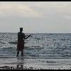
PickerelHunter Posted August 20, 2011 Report Posted August 20, 2011 Hey Guys...heading out on Tuesday to the French river where it meets Georgian Bay for 4 days of camping/fishing. The guy I'm going with has a cottage on the Key River so he knows the area around the river mouth fairly well but hasn't gone out much further west of that and has always wanted to. I've done a couple days worth of research on the area on the web and on this website and found quite a bit, but most of it is about sections of the river further inland than we planned on going. Our main focus area will be from the Bustard Islands up to the Dalles Rapids. I've attached two pics of the areas we'll be fishing. We have 4 days of fishing so we can cover a lot of water, but it seems like there is A LOT of water to potentially cover. Pike is our number one target and from what I've read seems like they are pretty abundant in the area. I'll be dragging tubes around the smooth rock islands we run past as well for smallies like I've had a lot of luck doing in McGregor Bay near Manitoulin. Obviously some walleye would be a bonus as well and we'll be looking for them in the evening. The area is so large I was hoping someone could direct us in the right direction for some pike action. Also some walleye areas in the main outlet of the French itself. It's impossible to tell from the maps where the weeds are etc. Any help would be greatly appreciated.
John Posted August 20, 2011 Report Posted August 20, 2011 Don't know the area below Dallas Rapids at all but have talked to guides who do and according to them it's a rock and shoal nightmare out there for those who are new to the area. The one guide who has 30 years running Dallas down to the bay says that he finds at least a couple of rocks he never knew were there every year. The guys I know run 20' Alaskans with up to 90 tillers. I would carry an extra prop for sure.
PickerelHunter Posted August 21, 2011 Author Report Posted August 21, 2011 Thanks for the heads up John...I know that entire area is brutal for rocks. Out in McGregor Bay within the first 15 minutes we had to change props! We will be keeping our eyes open for sure.
brw Posted August 21, 2011 Report Posted August 21, 2011 Pickeral: Have fished that general area (but not necessarily the French) for over 30 years now. If you can get a copy of Chart No 2204 (Key Harbour To French River/Canadian Hydrographic Service) it would be an enormous help to you. If you follow the bouy markers from The Key to The French, you'll eventually meander around Obstacle Island--It's near the "French River/Eastern Outlet" on the chart. The entire area around that Island, and the adjacent bays/coves, hold a lot of big pike and muskie. As you near that area en route to The French (just west of Dock Island), you'll see a nice cabin, where you will eventually make a hard right to follow the channel markers. The area near the cabin, as well as the small bay behind it, is a great pike/musky area. So is the general area from the cabin to past Obstacle on your way to the French. Might be worth a troll on your way over to or return from the French. It is also somewhat protected from wind if weather gets rough. You're right about it being an incredible amount of water to cover. Every shoal and bay looks like it holds fish. Can be paralyzing at times. My general rule is to stick to 5 to 22 ft of water or so, as over 90% of my fish are caught in that range. I usually fish that area in June so not sure whether that area will still hold pike but I have to believe it will. Large Rapalas, Williams Wablers, and swimbaits will all do the trick. Good luck
irishfield Posted August 21, 2011 Report Posted August 21, 2011 Rocks... in the delta of the french..
PickerelHunter Posted August 21, 2011 Author Report Posted August 21, 2011 4eyes thanks a lot for you info. This will no doubt help us along the way. I have found on the Hydrographic Website chart #2204, but the name has changed to 'Byng Inlet to Killarney'. Geographically this look like the correct map but since the name is different I just wanted to make sure. Any ideas where I could find this particular map? You can't order directly from the website. I found some dealers in the Barrie/orillia area but I doubt they have all maps, I guess a few phone calls will be in order. Irishfield Great pics...clearly it is a very typical canadian shield rocky area. Looks gorgeous though!
brw Posted August 21, 2011 Report Posted August 21, 2011 4eyes thanks a lot for you info. This will no doubt help us along the way. I have found on the Hydrographic Website chart #2204, but the name has changed to 'Byng Inlet to Killarney'. Geographically this look like the correct map but since the name is different I just wanted to make sure. Any ideas where I could find this particular map? You can't order directly from the website. I found some dealers in the Barrie/orillia area but I doubt they have all maps, I guess a few phone calls will be in order. Pickeral: That is the chart. the Key-to-French chart is one of 4 in that series, all under the "Byng Inlet To Killarney" title/ No 2204. I ordered it online a few years ago but I can't remember where. I just googled the name/chart no and it came up... Question: does your friend know of any places closer to The Key to fish? Seems like the French would be a long haul from there unless weather perfect and you have a high HP engine/rig.....
PickerelHunter Posted August 21, 2011 Author Report Posted August 21, 2011 (edited) Just chatted with him. The general plan is to launch out of the key river on Tuesday and head out to fox bay area to set up camp. From there the fish will basically determine where we head etc. But our general area will be Fox Bay and west to the main outlet of the French, and south to the Bustard Islands. He wants to shoot up to the Dalles rapids one of the days and work our way down. Other than that we don't have a specific gameplan. Once I get that chart (found one in orillia) and all his maps we'll have a better idea. He has a decent boat 16 or 18 footer with 40 hp I believe so if we stay out of the wide open water we should be alright. Edited August 21, 2011 by PickerelHunter
brw Posted August 21, 2011 Report Posted August 21, 2011 Just chatted with him. The general plan is to launch out of the key river on Tuesday and head out to fox bay area to set up camp. From there the fish will basically determine where we head etc. But our general area will be Fox Bay and west to the main outlet of the French, and south to the Bustard Islands. He wants to shoot up to the Dalles rapids one of the days and work our way down. Other than that we don't have a specific gameplan. Once I get that chart (found one in orillia) and all his maps we'll have a better idea. He has a decent boat 16 or 18 footer with 40 hp I believe so if we stay out of the wide open water we should be alright. When you get your chart PM me. I can go over it w/ you and mark some great spots as that is the general area I have fished for yrs....


Recommended Posts
Create an account or sign in to comment
You need to be a member in order to leave a comment
Create an account
Sign up for a new account in our community. It's easy!
Register a new accountSign in
Already have an account? Sign in here.
Sign In Now