
jedimaster
-
Posts
3,472 -
Joined
-
Last visited
Content Type
Events
Profiles
Forums
Store
Posts posted by jedimaster
-
-
i wish i could paddle that fast
Nah you don't...Trust me. at 80mph I was wishing I could just hold on and not get knocked unconcious by a bug.
-
I take it your not from canada? My cousin had an xb 2002, just traded it in for an xb 2003. Haven't been on the 2003 but I was in the 2002. The only complaint I had about the 2002 is that it is about as wide as my sportspal canoe.
 Very tippy on open water and the rear casting deck is very very small.
I don't recall there being a cowl on the rear deck on his. Is that a factory add on? It would make fishing from the back a little bit difficult wouldn't it?
Was that a stock option 2.5 outboard from the factory? How many ponies is it putting out? Assuming I spot you a 6 percent slipt and a 1.78 gear ratio(You mention its a stock gear case, that would mean you were cranking out around 8000 rpm's.
Thats one hell od a motor. How much gas does that thing suck.
Sweet boat man.
-
I used to have a spoon the shape of a pair of boobies. (.Y.)
-
Anyone knw how much it would ost for a family of 4 to get charter for Salmon or Lake trout on Lake ontario or Simoe? A friend at work may be interested in takng one.
-
Here is a thought. Why not organize our selves into a private restocking group and apply to the goverment for grants to help fund a restocking programme as well as using private funded dollars by organizing catch and release derbies on the lakes we stock.......nah that makes way to much sense. It would never work.
-
I would think a hundred thousand dollars would buy about 110 thousand fry. That would at least feed some of the crappy in rice lake.
I saw a survey that sai dit cost 706thoussand to buy 830 thousand walleye fry for an anual stocking program in the US.
-
Busy all weeked didn't get a chance to answer the questions.
Why not just upload the garmin blue charts? Several reasons. Its damn expensive to buy all of the regions and if you fish in alot of areas it would be thousands to get them all. If you have 3 gps's your only allowed to upload it onto 2 of them. The unlock policy is really restrictive that way. Also if you have a paper map of a depth chart but want it on your gps you can use it as a guide for marking the depth contours. I was also able to use a different program to convert a jpg scan of a depth chart and convert it to a depth chart for my garmin gps. That was significantly more complicated but it worked out very well.
Step 11 should be mapsend, Mapsource does not allow you to upload individual custom created img files, at least I wasn't able to.
The diffrence between creating a bunch of routes and waypoints is you can only activate a single route line on a handheld gps at one time, so you could only see one contour line. This method allow syou to trace out the entire lake and have it viewable all the time. You need to convert the route lines you have traced over to depth contours for them to show up.
Yep a billion programmes say they will work but if you use the ones I mentioned it will work.
Yah I fixed a few streets on my maps as well, as some bottom structure, rock pillings, marker bouys etc... great if you fish at night and don't want to run into unmarked bouys.
I hope that answered most of the questions.
-
Ok I have gotten several email regarding a po I made about being able to create and convert bluecharts to upload to garmin hand helds.
Here is what I am doing. Make sure you read the warning below.
It was definatly not easy to figure out but its not as hard as it seems. It took me several months to figure out the right combo of tools and how to actually get this to work because to my knowledge NO ONE on the internet has been able to directly or indirectly export and edit bluehcarts.
Yes I am tooting my horn because I am the man. hahaha
Here is a breakdown. Don't ask me where to get the programmes just go google them.
1) Open up Mapsource and load the bluechart for the area in question
2) Trace over the depth contours with the route tool
3) Save the route lines into a GDB file
4) Open up GPSMapEdit
5) Open up the Topographic IMG file for the lake your working on.
- The topo of the lake will serve as the bas map for your route lines...It would be easier to just use the bluechart img but they are encrypted and it hasn't been broken yet....
6) Click File then Add and select the GDB file with all the route lines.
7) Click on all of the route lines and change them from route lines to depth contours, major or minor it doesn't really matter unless you have a color gps unit then you should make the shllow one minor and the deeper ones major, I find it easier to read on my black and white one to make them all major contour lines
8) You can also edit the map, add whats his name areas, docks, gas stations, roads, launches etc...
9) When you done export this as a Polish File.
10) Then export it as a garmin IMG file.
11) Open up Mapsend and upload the img file to your GPS.
Now Bob really is your uncle and the Jedimaster is Bob.

Now for the legal warnings that you have already agreed to by reading this.

If you screw up your gps don't come and complain to me, its easy to mistakenly screw up the gps base map. Also if you accidentally move any features on the topo map your coordinates will be way off. Its very easy to unknowngly move a lake or move a road. Trust me I flooded Port perry several times. I had a killer water front house for a while though.
I would think you should use this as a structure finding tool and not a navigational tool, be careful when your on the lake. Don't sink your boat. I take no responisbility if you injure yourself or others by using this method. Nor do I even know if your allowed to edit maps so if you get busted don't come to me.
-
Those fatboy rims and tires are apparently very good if you have clearence issues.
-
My boat has odd ball hubs and rims, they are 13" 4 bolt. I found some great trailer tire rubber for them though. previously I had car tires on because I couldn't find anything else that would work. and it makes a big difference on sway when trailering thats for sure. Go with trailer tires and get the biggest fatest wones you can cram under your wheel wells.
-
Just make an alarm clock that instead of ringing it has a spring loaded boxing glove pointed at your nads with a servo attached, and when the alarm goes off well use your imagination.
-
I mean I think we have all missed the REAL question here. Why would you need a box if all you had is one bait? Why not just tie it on an leave the box at home?
-
White Spinner Bait
Then a White Mister Twister on a Rattling jig head
Then a worm harness
-
A stick of dynamite.
-
true enough
-
Fairly dissapointing on the test in that PDF.
Few if anyone will nto buy a boat because of this. But what they could have done is better compare the two major classes of boats.
IO's and Outboards.
They didn't have complete results for the 150 outboard, only idle numbers.
It would have been better for them to compare two identical boat designs 1 outboard and one IO. That would cause me to sway one way or another.
Either way The results from the IO open cockpits seem pretty reasonable.
The CO from a 14 foot tin boat with a 40 2 stroke was higher than a an IO.
Most people are under the impresion that IO's are worse for CO. I don't belive that is the case. Maybe if you backtroll and stick your head in the bilge. But a good boater has the blower on in an IO and the engine compartment is for the most part sealed. Maybe next time I am out on the water I'll bring my at home CO detector and see under what conditions it will go off.
-
a 2 ounce bottom bouncer and floating crankbait works good from a canoe.
-
I guess if I ride around in the ski locker I would be more concerned about CO levels.
Whatever you do make sure you buy what you want not what everyone else thinks is best.
-
Fish and Ski's are leaned one way or the other. You can buy a Bass boat/Ski Boat. You can buy an alluminum fish n ski, you can buy a bowrider fish n ski.
Whats the primary use and what water boady are you on? Is it going to be trailered or in a slip, at a cottage etc... How many people are going to use it regularly? Small kids? How fast do you want to be able to go and how fast are you going to want to cruise at? Do you want a better fishing boat than a Ski boat or a better ski boat that you can fish from. Are you going to fish for walleye, Bass, Lake Trout, Salmon, perch etc...
I personally find the best all around boats to be Inboard fiberglass bowriders that can convert to fishing boats. Rinker, Glastron and Fourwinns make nice ones. The offer the most seating, and deck space for fishing(if you get an inboard)
If you want one leaned towards Bass fishing, Allison and Skeeter make nice ones. The XB 2003 can be moderatly considered a fish 'n ski(100 mph fish an ski hmm) The skeeter SL serires is more reasonable and sedate.
For a Walleye or Lake trout I would go with a Lund Sport and Fish Boat. I like the Lund 186 Tyee
Budget is the biggest thing. Also new or used.
-
Sadly I didn't wake up, had company over and had a few beers.
Anyone else fish during the eclipse? -
You can also replace your fish at the lake too

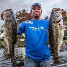
Nice fish and setups people!
Yep gets new fish almost everytime out. Sadly though the Pickeral, Perch and Crappie mortality rate in my fish tank is very high.
-
I have a 40 gallon, and it has pike, walleye, bass and Lake Trout. It gets a 100 percent water change every time I go to the lake.
-
-
Tuesday Morning from what I know. like 5 am or something.
Supposedly the theory is that when an eclipse happens on a clear night Walleye go bananas because the preasure should say clear skies and go eat everything in sight, but it is darker out so they get all freaked out.
I dunno, sounds bit fishy, but I may go early am and try and hit a few.
Basically tonight is the eclipse the it will run from 4:51am to 8:24am Tuesday morning.
New Member
in General Discussion
Posted
3.0 mercruiser baby, I can run fish and go tubing for 2 full weekends on 90 bucks of gas....and no need to add oil.