

Sterling
-
Posts
477 -
Joined
-
Last visited
Content Type
Events
Profiles
Forums
Store
Posts posted by Sterling
-
-
Sounds like an honest mistake. I'm sure they'll be willing to modify the rules to be compliant.
-
44 minutes ago, bassnass said:
I don't know... I typically run with a tablet, my phone and my handheld - I find the handheld gps picks up signal faster, is more accurate, and updates quicker than the other two (at least once a second if not faster). I don't trust my phone or tablet near as much as my handheld.
Lots of people running phones and tablets with "assisted GPS" which is a half-arsed GPS system. You need a real GPS, preferably with GLONASS.
-
41 minutes ago, pike slayer said:
Ya definitely no cell service at dog lake. Get yourself a garmin
Don't need cell service, just GPS. Any tablet or phone with navionics + GPS will outperform most (if not all) dedicated units overall.
Edit: This is of course, strictly for on-water purposes.
-
Super nervous about my trip up in James Bay in early June.....
-
7 minutes ago, grimsbylander said:
Agreed. I don't target suspended fish so rarely ever use electronics to look for fish. I'm not sure how you use it for fishing docks either? Do you drive past all the docks first to decide which ones hold fish? I catch fish all the time that don't show up on my electronics and that's on a clean bottom...not sure how reliable it would be with weed growth under a dock? I'd like to hear more about your process. As for the 240 ft per side....not my numbers. I have HDS units and get great data out to about 150 or so. That's a 300' swath and like previously mentioned, I can spot structure, zoom in, lay down a waypoint, and circle back on it. I also have a Point 1 antenna so I know exactly where I'm facing and how far out the waypoint is. This is extremely handy in water 15+ feet or more. This is my method for breaking down large targets areas such as points. Instead of fishing the "point", I'll do a 5-10mph fly-by and lay down a bunch of waypoints on any good looking structure that on the point. Then fish those waypoints only. Makes breaking down a point, saddle, hump, etc much quicker and I only fish the good structure on the structure.
Not 100% sure of the details but at the bow of my partner's boat is a helix (I think). We swing around near a dock, say 25-30ft out and with the proper orientation SI scans under the dock. The dock pillars will show up strong and are easy to interpret. Using the dock pillars as reference you can easily see whether there are larger fish hanging around. Then it's just a matter of knowing where to cast. Where this was used (Temagami) weed growth isn't a big problem as the lake is very rocky. Every dock and structure gets a few casts regardless, as you mentioned fish can hide...
-
12 hours ago, grimsbylander said:
Huh???
Maybe we used a different technology or something, but there's no way I would be able to interpret SI 240ft out. Disclaimer: I don't have SI on my boat but my fishing partner does.
Where it really shined was checking docks for fish (bass) which was in very close quarters.
Then again it looks like you're using SI for locating structure while I'm using it to find fish.
-
Incredibly useful when going after bass around docks, for example.
Useless when fishing deep water.
-
1 hour ago, SirCranksalot said:
I assume you are kidding about that! I wish it was true, though.
I guess this could start a pretty heated argument. But no, I wasn't kidding. And I thought this was a common understanding among anglers.
I stash a tinner or canoe at a super remote lake. It might see what, 1 use per year, if that? And they're usually beaters too. Sometimes they're tied to a tree - that to me is owner saying "please no touchy" and I respect that.
Treat the gear with care and I don't see an issue.
Sorry for derailing!
-
Memory is a bit shady because it's been so long, but here's what I know...
You can get trailered into the lake by launching at Mowat landing and driving up to the guy at the dam. He's crabby but mellows out after a drink or two.
The west end of the lake is considered a provincial park and you need a permit ($$$) to camp there. The east end is fair game.
West end is deep, east end shallow. Navionics has an excellent bathymetric map of the lake. You should check it out.
On the way in you'll see sand hills on the right, this is where we nailed walleye in the early season. No luck anywhere on the east end later in the season as fish go deep.
Nailed bass at the falls connecting Lady Evelyn and Diamond. In fact this was probably the best bass fishing I've ever experienced.
There are lakers in there as well (apparently) but I never targeted them.
Southeast end of the lake has a portage leading to other small lakes, one of which is stocked with rainbows. There are canoes on the lake there that are fair game as per universal angling laws.
Do us a favor and post a report when you get back!
-
Depends on the species and the type of cleaning I want to do! Perch I can clean in less than a minute using this approach:
Otherwise it's just over a minute per fish if I'm cleaning the conventional way.
Walleye takes me a few minutes but that's because I've perfected the art of recovering 95% of the meat. It can be done pretty fast if you're this guy;
-
Very rewarding catching fish on tackle you made yourself. I'm working on some worm harnesses of my own now.
Only time I ever caught anything on my own tackle was an awful painted spoon. Trout naturally ate it anyway.
-
29 minutes ago, BillM said:
Bug spray, lots of bug spray. I've never seen black flies like that before on my last May trip there. I'll be leaving as you'll be showing up
") Good luck!
Good luck!
Don't forget to load up on gas.
On that note, they finally started making proper bug suits that aren't annoying to wear. I bought one of these https://www.mec.ca/en/product/5016-843/Polyester-Insect-Proof-Shirt
and ended up getting 2 more.
Secondly, you can buy deet spray from the USA. I know it's bad for the environment and stuff, but if it's one spray here and there, little harm done.
Third, try permethrin. Also not approved in Canada but the military uses it. It was invented for use in Vietnam. You spray it on your clothes and it works even after washed. I tried it last year and it was awesome.
-
1 hour ago, icefisherman said:
Sorry, should have mentioned that...
Live West of GTA. Considering we are going for a week up to 12-13 hrs of driving is fine.
Cheers,
Ice Fisherman
If you're willing to drive that far why not go to Quebec? You could make it to Mistassini which as far as I'm concerned, is the best fishery in the world. World class walleye, pike, lakers, and specks. Everyone there speaks english so that's not an issue.
Or you could go to say Lake Golean which is renowned for walleye. I fish this area yearly and the quantity is just insane, size not so much. 23 inch is the biggest you'll get, and 25+ is a trophy.
Otherwise maybe consider Nipigon?
-
Where do you live and how far are you willing to travel?
-
2 hours ago, Dutch01 said:
Those bugs have now killed a person (perhaps a couple more that I am not aware of).
Human drivers killed 1,858 people in Canada in 2015 alone.
Define acceptable.
Has it been determined that the fatality was caused by a bug? Or would have this happened anyway?
-
Some pretty major hate toward AVs in this thread! Not surprised though considering our average audience (crusty old fishermen - no offense guys...)
On a more serious note, I have to agree with Dutch.
There is no debate. AVs are safer. Let's start counting up the tens of thousands of hours AVs have without at-fault collision or fatalities. AVs are superior in every single way. The decision not to "trust" AVs is an emotional one only, this cannot be debated. For every fatality caused (despite) autonomous behavior, how many lives were saved? I would suggest starting with Tesla's AV videos, these will blow your mind. Instant and intelligent collision avoidance. Not only does the vehicle avoid the collision, but it does so in the safest way possible.
AVs don't speed, get tired, drunk, drugged, sick, distracted, or injured. They see through fog and whiteouts. They slow down during freezing conditions. Have instant reflexes. Eliminate gridlock. Can drive at night while you sleep. Save you on plane tickets. Allow you to work while traveling. Save money on insurance. The list is endless.
Ask yourself this; do you trust yourself more than AVs? Possibly.
Do you trust AVs more than the average driver? Hell yes!
-
39 minutes ago, drwxr said:
Not sure how you ordered, but the website been down for a while now (since 2015), All their left over stock was picked up by sail stores.
According to webarchive the site was up and regularly updated up until recently.
-
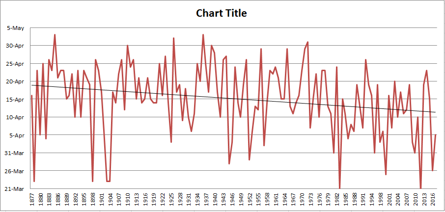
1 hour ago, AKRISONER said:
that chart basically shows how global warming is happening lol
First thing that came to mind as well. I wanted a visual representation and made this;
-
On 3/9/2018 at 8:41 AM, AKRISONER said:
You know iron, thats funny because my experience with fall walleye is that if im not in my 20 foot "box" im not catching at nearly the same rate...its so precise that GPS waypoint gets you close but its actually visual alignment that gets it perfected. We had a morning last year that for whatever reason I was fishing the front of the boat...i caught 28 walleye that morning, while the rest of the boat caught a collective 5.
The other scenario where electronics absolutely changed the game...shoal drop shotting smallies. I have a few spots in late september that are rocks in a giant basins...they are so random that navionics charts sort of mark them but its not very accurate and a few arent even charted at all they were found using a friggin pirahnamax and became honey holes later...they are marked on my units now and ive even autocharted them now so that I actually have an exact "graph" of whats going on down there that no one else in the world probably has.
The poorly charted spots show a depth change but dont actually precisely show where the reef actually is...The actual reef itself is probably only 15x15.
ipilot helps an absolute ton, especially with the new jog feature on the terrova's...it allows you to stay on target but shift 5 feet to the left right front or back to make sure you work over that one particular spot. Im back to a cable drive now so I will be bringing marker buoys with me to throw down for a visual cue of where the heck i need to be sticking to.
The results speak for themselves
I used to think electronics were a bit overrated, and in shallower lakes with a whole pile of weeds, imaging isnt as essential IMO...i.e. when im fishing shallow for largies my electronics are basically turned off. But you start fishing that 15+FOW on clean structure, finding deep weeds, random shoals in big bodies of water...I literally owe some of my best catches to my sonar and GPS.
My PB walleye, we drove up to the edge of a shoal that once again is very poorly marked, flipped on the electronics found the actual edge of whree the bottom of the basin started to run up...sure enough marked a tank of a hook on bottom, the thing had two bloody fish icons on it...dropped the drop shot down and instantly hooked up.
I have to agree with you Akrisoner.
To me electronics make the puzzle solving even more fun, especially in the fall when 5% of the lake holds 90% of the fish. I'll often start my search for fish with a thermocline check with my temp probe, then switch to navionics and find sunken islands / humps that nicely intercept this thermocline. Then mark all of these, and travel from one to the other until I see fish. It works.
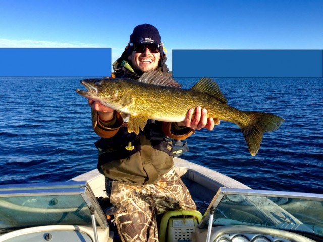
I knew the location of your 2nd picture instantly btw, those 2 blue buildings are just down the road from me

Edit: I should add, on my home lake I use electronics for depth only maybe 90% of the time. I know where the big fish are and I just stick to that approach throughout most of the year.
-
I see lots of successes and no failure?
I did well with the following;
- Bitcoin, going back to 2013. Do not invest in any cryptocurrencies aside from bitcoin and MAYBE the other top 5, Do not invest in cryptocurrencies if you don't understand them. Do not invest in cryptocurrencies if it's in the news.
- Cobalt ETFs (this one will be a top performer in the coming years).
- Various mining companies including Freeport McMoran.
- Various collectibles which will not be named.
I did poorly with the following:
- Gold mining companies including Goldcorp.
- Weed stocks (never bought, ha).
I have my sights set on:
- Nickel ETFs, particularly high latterite nickel mining companies...
- Cobalt cobalt cobalt
- Lithium
On 1/26/2018 at 1:00 PM, Garnet said:Bitcoin chain letter / Ponzi. Nobody remembers the 1 st CEO committed suicide .
The hell is a bitcoin chain letter?
-
5 hours ago, 16 Footer said:
My son In law and 3 buddies just returned from their annual trip to Hyatt's huts. They caught lots of small pike and all the walleye were under slot. They did not look too happy with a few perch they brought back. They also said Rob Hyatt is selling his hut business but keeping his chalet.
Nipissing is primarily a catch and release fishery, at least for walleye. No fault of the outfitters. They have it rough with the new slot size, it really impacts their business.
-
Great video, hard to find these meegs jigs online, damn.
-
You can get the perch rigs / pickerel rigs for $1 at Walmart. I'd just go that route. They're a bit bulkier but seem to work fine.
Lures should be tied to the line you tend to. Other lines should have live bait!
-
1 hour ago, Joeytier said:
As far as I know, every Helix uses CHIRP technology.
These shoals are full of herring, so we see tons of marks in the upper half of the water column. I keep a split screen on my unit, one zoomed in on bottom few feet. Usually won't mark intended quarry up high but somedays you have to work them way up the water column to get a strike.
Yeah, I see big arches in the upper column in the summer but I don't think this applies through ice. My buddy has a flasher that is either zoomed in or out, no secondary chart. Might not be a big deal.
The unit I was looking at was a G1. Those don't have CHIRP. The newer units (G2) have CHIRP sonar and CHIRP DI.
Be wary of DI - I tried it through ice and was missing arches. That's because DI is a narrow, oval shaped sweep meant to be used on a moving boat. Doh.
With CHIRP sonar you're golden though. Based on your video it seems like you're capturing everything.
GPS Unit, recommendations?
in General Discussion
Posted
Good information. Some additions to what you've said;
Navionics is free for phones but you have to pay for the tablet ("HD") version. The HD version allows you to use Navionics on larger displays. I think it's $40?
Regarding battery life, it's essential to hook up your unit to some sort of power source, otherwise you're out of power within 3 hours or so. My boat battery charges a tablet faster than it drains. As you pointed out, cold can be an issue, but the main problem I encountered was excessive midsummer heat, where the unit was at first sluggish, then turned itself off. Blazing sunlight is another problem if you're in the open. Funny enough a white unit will absorb less heat and cope with this problem better.
Dog Lake doesn't seem to be charted. Navionics will often use available maps (government maps for example) to chart lakes. Then anglers fine-tune it by uploading their data. Dog Lake has some data available but not much. This will only get better with time. If Navionics doesn't have it, odds are it's not available elsewhere. Could be wrong though.