Stein
-
Posts
22 -
Joined
-
Last visited
About Stein

- Birthday 03/22/1967
Recent Profile Visitors
635 profile views

Stein's Achievements
Minnow (2/10)
0
Reputation
-
Garmin Nuvi 760. It's great, voice prompts, great routing so far and you can get refurbs from amazon.com for $199. Mine was listed as a refurbished but I can't tell it from new.
-
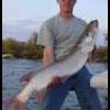
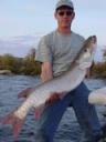
That smallie is fricken awesome!
-
Rocks over weeds is fine with me! I like jakes, grandmas and big cranks that time of year anyway. I suppose I will have to still throw the DCG's as well, but I really don't like winching those things in. Anyone that says they can burn them all day either is lying or has my utmost respect.
-
I appreciate the update tjsa. I didn't know if anyone stretched up that way much. It was worth a shot, though. I'm sure I'll figure it out in the first couple of days. It's part of the hunt.
-
I know that I'm a bit early asking as I don't get to come up for two more weeks, but can anyone give me a muskie report for Minaki/Roughrock/Big/Little Sand area or is anyone going in the next week or two? Not looking for spots as we have been going for the last 15 years now, but with the cooler summer are the fish shallow, on rocks, on weeds, etc? Looking forward to 10 days of muskie fishing bliss. No work, no phones, ahhhh. Can hardly wait! Feel free to PM if you don't want to post here. Thanks!
-
That HAS to be the first time a Drama rod has EVER been on a downrigger.
-
I've become a big fan of floro leaders, but I tend to stay with 130 lb leaders. A bit better biteoff protection. If you believe internet lore, there have been biteoffs on 100 lb, but no confirmed cases on 130 that I am aware of, so I think that is kind of the tipping point. I use them on everything except jerkbaits. You will want to stay with a stiff single strand on them for proper lure action.
-
Taper, one thing I am considering doing is the following that I got from another board. It would allow me to waypoint humps, etc. that aren't visible. It may help you also. I can take scans of the Canadian Hydrographic maps that I have and use them. Here is a Copy and Paste of what he did: I had a great old paper map, and thought there has to be a better way than riding around with a map on your lap, looking for that hump that you want. One day while playing around with Google Earth, I found a button where you could overlay images onto it. I scanned my paper map in sections, then using Adode Photoshop,pieced it back together, erased everything outside of the lakes banks, converted it to a GIF image for transparency, then saved it on my computer. Then it's simply a matter of importing it to Google Earth and lining it up with the satellite image. I was suprised when it fit perfectly. I could then run my mouse across the screen, hover over whatever I wanted, and get the GPS coords for it, and enter them into my GPS manually. It actually worked better than I thought it would, and alot easier than riding around with a map in your lap.
-
Does anyone know of ANY GPS chip that covers the Winnipeg River area around Minaki? Any detail would be better than nothing. I haven't been able to find anything. Buying a new GPS plotter this year, most likely a Lowrance 520c and would like to have a map of this area for our September trip. Thanks, Stein
-
While I would agree that it would be a great show-- any cold weather series would be a great test, we'll never see it. Gotta give the audience girls in bikinis.
-
also take a look at the articles in the Library here: http://www.rodbuilding.org/library/library.html and check out the message board here: http://www.rodbuilding.org/list.php?2
-
The bass guys down here go nuts over those things. For most of them, they are the only cranks they throw.
-
Why would there possibly be a "Fishing Hurts" banner ad running on the OFC Homepage linking you to fishinghurts.com on a fishing forum??????
-
I caught two rocks within an hour. The second one was about softball sized, but flat. Felt like a fish. We have now caught five rocks from this lake (Milford Lake in Kansas) The rock is limestone with lots of holes and the hooks of crankbatis will snag in the holes. Never seen so many boated rocks.
-